GFM
SCEC Geological Framework Model (GFM)
Contents
Description
The SCEC Geological Framework model is a 3D model of California geological regions. Given a lat/lon depth (or elevation) the GFM will return properties for the given point, including Geological Region Name, and temperature.
GFM Voxel Data
Web viewer prototype
SCEC has developed a initial GFM web viewer page based on the GFM data Andreas provided us with earlier this year. There are two parts to this GFM site.
Behind the scenes, this webviewer uses a modified version of vx-lite that can read the GFM dataset. If wanted, users can download this vx-lite code, and the GFM voxel data set, and use vx-lite to query the GFM on the command line.
Then, we created a simple GFM web viewer. The webviewer calls the modified vx-lite code to query the GFM
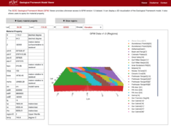
The GFM webview enables user to query the GFM for a single point, using either query by elevation or query by depth. The user enters the lat/lon and Z and presses "Query Material Property" and the webpage shows the cvm-h data for the point, and new GFM data including RegionID (and Region Name), and Temperature.
This prototype GFM Webview also can plot the full GFM data volume. user's press "Show regions" and a decimated version of the GFM data set is shown. Users can rotate the volume, and the cursor will show the region type for any point selected. Users can turn on and off regions, by clicking on the region names on the right of the screen.
This is a very preliminary prototype, but we may be able to get a few changes in before the annual meeting. Please let us know what changes you'd like to see, by emailing software@scec.org
Data files
- GoCAD Metadata file (txt) for 10x10x1km resolution grid of volume (1.7KB)
- Media Temp Data Grid (3.5MB)
- GFM Region Id Grid (3.5MB)
- CVM-H v15.1 as CSV file (45.4MB)
GFM Command line distribution
The current GFM can be distributed as a stand alone program that users can install on Linux computers. This program is a modified version of the CVM-h distribution program called vx-lite.
This software is posted at:
git clone https://github.com/SCECcode/cvmh.git -b forGFM
The build instruction:
## $CVMH_INSTALL_PATH => user preferred location
## $uid => user's uid to access hypocenter's cvmh data location

cd cvmh
aclocal
automake --add-missing
autoconf
./configure --prefix=$CVMH_INSTALL_PATH
cd model
./make_data_files.py -d cvmh1511 -u $uid
cd ..
make
make install
To Test:
cd $CVMH_INSTALL_PATH
cd bin
./vx_lite -h

 vx_lite - (c) Harvard University, SCEC
Extract velocities from a simple GOCAD voxet. Accepts
geographic coordinates and UTM Zone 11, NAD27 coordinates in
X Y Z columns. Z is expressed as elevation offset by default.

	usage: vx_lite [-g] [-s] [-m dir] [-z dep/elev/off] < file.in

	       or
	       vx_lite [-g] [-s] [-m dir] [-z dep/elev/off] -l lon,lat,depth

Flags:
	-g disable GTL (default is on).
	-s directs use of SCEC 1D background and topo.
	-m directory containing model files (default is '.').
	-z directs use of dep/elev/off for Z column (default is offset).

	-l lon,lat,depth.

Output format is:
	X Y Z utmX utmY elevX elevY topo mtop base moho hr/lr/cm cellX cellY cellZ tg vp vs rho regionID temp

Version: 11.9.0
mei@ip-172-31-31-151 bin]$ ./vx_lite -m ../model -l 34.2,-117,0
{"X":-117.0000,"Y":34.2000,"Z":0.00,"utmX":500000.00,"utmY":3784136.85,"elevX":499875.00,"elevY":3784125.00,"topo":1715.29,"mtop":1750.00,"base":1714.11,"moho":-36599.68,"src":"gfm","cellX":2124.00,"cellY":1497.00,"cellZ":748.00,"tg":15.00,"vp":1076.52,"vs":374.00,"rho":1319.29,"regionID":13,"temp":-99999.00}
[mei@ip-172-31-31-151 bin]$ ./vx_lite -m ../model
-117 34.2 0
   -117.000000       34.200000      0.00  500000.00  3784136.85  499875.00  3784125.00   1715.29   1750.00   1714.11 -36599.68 gfm    2124.00     1497.00    748.00     15.00   1076.52    374.00   1319.29 13 -99999.0000
