Difference between revisions of "CyberShake Central California"
| (2 intermediate revisions by the same user not shown) | |||
| Line 2: | Line 2: | ||
=== CyberShake Box === | === CyberShake Box === | ||
| − | + | The proposed CyberShake box (in which CCSP CyberShake sites will fall) has dimensions 180km x 240km, at an angle of 35 degrees. Its coordinates are: | |
| − | The proposed CyberShake box (in which CCSP CyberShake sites will fall) has dimensions 180km x 240km, at an angle of | ||
*Southern corner: (33.8, -119.93) | *Southern corner: (33.8, -119.93) | ||
| Line 10: | Line 9: | ||
*Eastern corner: (34.76, -118.35) | *Eastern corner: (34.76, -118.35) | ||
| − | Below is an image of the proposed box (in magenta; Southern California CyberShake box is in black, CCA region is in blue), with a kml of it [[ | + | Below is an image of the proposed box (in magenta; Southern California CyberShake box is in black, CCA region is in blue), with a kml of it [[Media:CCSP_CyberShake_Box_kml.kml | here]]. |
[[File:CCSP_CyberShake_Box.png]] | [[File:CCSP_CyberShake_Box.png]] | ||
| + | |||
| + | === Site selection === | ||
| + | |||
| + | We have identified 5 classes of sites to include, totaling 472 sites. A KML file with the sites+names (10 km grid in yellow, CISN stations in orange, USGS cities in red, PG&E pumping stations in purple, and missions in blue) is available [[Media:CyberShake_CCSP_candidate_sites.kml | here]]. | ||
| + | |||
| + | # 10 km grid: 302 | ||
| + | # CISN stations: 112 | ||
| + | # USGS cities: 28 | ||
| + | # PG&E pumping stations: 4 | ||
| + | # Missions: 6 | ||
| + | |||
| + | For each class, we have identified the sites which fall within the Central California box but not within the Southern California box. One of the PG&E pumping stations is just over the border, but we decided to leave it in. | ||
| + | |||
| + | 240 CISN stations fall within the Central California box. After eliminating stations which were within 0.05 degrees (~5 km) of each other, 132 stations remained. We also eliminated CISN stations which were within 2 km of another site. | ||
Latest revision as of 15:37, 13 July 2016
We are planning to perform CyberShake studies in Central California, as part of the CCSP.
CyberShake Box
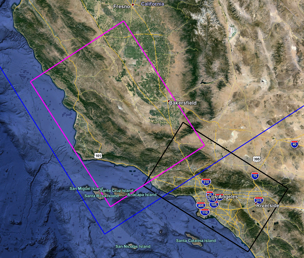
The proposed CyberShake box (in which CCSP CyberShake sites will fall) has dimensions 180km x 240km, at an angle of 35 degrees. Its coordinates are:
- Southern corner: (33.8, -119.93)
- Western corner: (35.52, -121.51)
- Northern corner: (36.5, -119.92)
- Eastern corner: (34.76, -118.35)
Below is an image of the proposed box (in magenta; Southern California CyberShake box is in black, CCA region is in blue), with a kml of it here.
Site selection
We have identified 5 classes of sites to include, totaling 472 sites. A KML file with the sites+names (10 km grid in yellow, CISN stations in orange, USGS cities in red, PG&E pumping stations in purple, and missions in blue) is available here.
- 10 km grid: 302
- CISN stations: 112
- USGS cities: 28
- PG&E pumping stations: 4
- Missions: 6
For each class, we have identified the sites which fall within the Central California box but not within the Southern California box. One of the PG&E pumping stations is just over the border, but we decided to leave it in.
240 CISN stations fall within the Central California box. After eliminating stations which were within 0.05 degrees (~5 km) of each other, 132 stations remained. We also eliminated CISN stations which were within 2 km of another site.
