Difference between revisions of "NorCal CyberShake SW4 Mesh"
(→22G) |
|||
| Line 695: | Line 695: | ||
<pre> | <pre> | ||
</pre> | </pre> | ||
| + | |||
| + | ==== sw4 plots ==== | ||
| + | |||
| + | {| | ||
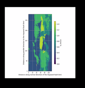
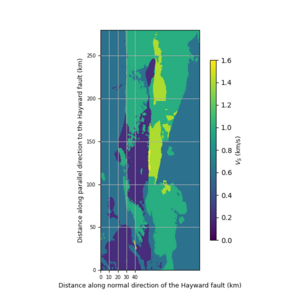
| + | | [[FILE:22g_view.png|thumb|300px|SFCVM ]] | ||
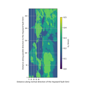
| + | | [[FILE:22g_taper_view.png|thumb|300px|SFCVM with taper]] | ||
| + | |} | ||
== Validate with depth profiles == | == Validate with depth profiles == | ||
Revision as of 06:02, 2 August 2024
- Create CyberShake Mesh for NorCal in 3 files (80m)
- Tile with background
Contents
Pre-study
goal: to validate the sw4 plot of sfcvm native hdf5 datafile via its gmg reader shows topography features at surface and yet
accessing UCVM's sfcvm is showing a chopped plot at Z=0
Frontier setup
modules :
module load cray-python module unload PrgEnv-cray module load PrgEnv-gnu gcc module load libtool/2.4.6module load Core/24.07 module load openblas/0.3.26
building UCVM
#!/bin/bash
#
hn=`hostname -d`
ppwd=`pwd`

export MY_TOP=$ppwd/scratch
export TOP_UCVM_TARGET=$MY_TOP/TARGET_UCVM_SFCVM

export UCVM_SRC_PATH=$TOP_UCVM_TARGET/UCVM
export UCVM_INSTALL_PATH=$TOP_UCVM_TARGET/ucvm_install

rm -rf $TOP_UCVM_TARGET
mkdir $TOP_UCVM_TARGET

cd $TOP_UCVM_TARGET
git clone https://github.com/SCECcode/ucvm.git -b withSFCVM UCVM

cd $UCVM_SRC_PATH/largefiles
./get_largefiles.py -m sfcvm,cca,cvmsi

cd $UCVM_SRC_PATH/largefiles; ./stage_largefiles.py

cd $UCVM_SRC_PATH
./ucvm_setup.py -d -a -p $UCVM_INSTALL_PATH &> ucvm_setup_install.log

echo "..EXITING.."
exit
SPECIAL NOTE 1:
on Frontier, the first time ucvm_setup.py call seems to fail when configure is called via script. If rerun by hand, It actually goes through.
         1) extract the configure command from config.log and run it by hand
         2) at UCVM top level, call
make clean; make; make install
3) make sure ucvm_env.sh is setup properly
./ucvm_setup.py -a -d -r -p $UCVM_INSTALL_PATH
4) source $UCVM_INSTALL_PATH/conf/uvcm_env.sh
SPECIAL NOTE 2:
for sw4, hdf5 needs to be enabled with parallel option,
           1) cd $UCVM_SRC_PATH/work/lib/hdf5
           2) extract the configure command from config.log, and rerun it with --enable-parallel
           3) and then call
make clean; make; make install;
building sw4
git clone https://github.com/geodynamics/sw4.git sw4-clone
git clone https://github.com/geodynamics/sw4.git -b ucvm_cmd sw4-ucvm_cmd
building sw4-clone,
add this file, config.inc, under configs directory
FC = gfortran
CXX = mpicxx

proj=yes
hdf5=yes
SW4ROOT = /ccs/home/mei/scratch/TARGET_UCVM_SFCVM/ucvm_install/lib/proj
SQL3ROOT = /ccs/home/mei/scratch/TARGET_UCVM_SFCVM/ucvm_install/lib/sqlite
HDF5ROOT = /ccs/home/mei/scratch/TARGET_UCVM_SFCVM/ucvm_install/lib/hdf5

EXTRA_LINK_FLAGS = /ccs/home/mei/scratch/TARGET_UCVM_SFCVM/ucvm_install/lib/openssl/lib/libcrypto.so.3 /usr/lib64/libopenblas.so.0  -L/opt/cray/pe/gcc/12.2.0/snos/lib64 -lgfortran
top level Makefile needs to be tweaked alittle..
diff --git a/Makefile b/Makefile
index 171d1c5a..ca1ef313 100644
--- a/Makefile
+++ b/Makefile
@@ -78,6 +78,8 @@ SW4LIB64  = $(SW4ROOT)/lib64
 #Default, override with configs/make.name. Preferably, FFTW is installed under SW4ROOT
 FFTWHOME  = $(SW4ROOT)

+SQL3INC    = $(SQL3ROOT)/include
+SQL3LIB    = $(SQL3ROOT)/lib

 emptystring := ""
 foundincfile := $(emptystring)
@@ -174,8 +176,8 @@ ifdef EXTRA_FORT_FLAGS
 endif

 ifeq ($(proj),yes)
-   CXXFLAGS += -DENABLE_PROJ -I$(SW4INC)
-   linklibs += -L$(SW4LIB) -L$(SW4LIB64) -lproj -lsqlite3 -Wl,-rpath,$(SW4LIB) -Wl,-rpath,$(SW4LIB64)
+   CXXFLAGS += -DENABLE_PROJ -I$(SW4INC) -I$(SQL3INC)
+   linklibs += -L$(SW4LIB) -L$(SW4LIB64) -lproj -L$(SQL3LIB) -lsqlite3 -Wl,-rpath,$(SW4LIB) -Wl,-rpath,$(SW4LIB64)
 endif
compile sw4 by
make
making sfcvm mesh in sfile format using sw4
building sw4-ucvm_clone is just the same as sw4-stock but it is alittle ad-hoc and so just assume it is done and the sfcvm_mesh.sfile is here..
ccs/home/mei/proj-geo156/ucvm/sw4/sfcvm.output/sfcvm_mesh.sfile
the sfcvm.txt used for generate this sfcvm_mesh.sfile,
# SW4 SCRIPT

fileio path=./sfcvm.output pfs=1 verbose=1 printcycle=10 nwriters=16

time steps=10

# GRID SIZE AND REFINEMENT
grid x=280000 y=115000 z=30000 h=100.0 lat=39.111563 lon=-122.569504 az=143.638 proj=tmerc datum=NAD83 lon_p=-123.0 lat_p=35.0 scale=0.
9996

supergrid gp=30
time t=0.1

globalmaterial vsmin=400 vpmin=800
attenuation phasefreq=1.0 nmech=3 maxfreq=10.0

ucvm filename=sfcvm.h100

# POINT SOURCE
source depth=8320 lat=36.86733 lon=-121.6105 m0=2.515e15 dip=80 strike=138 rake=-177 t0=1.0 type=Dirac

# Station
rec lat=37.52886 lon=-122.25522 depth=0 file=1002_37.52886_-122.25522 variables=velocity nsew=1 usgsformat=1 sacformat=0

sfileoutput file=sfcvm.mesh
and the slurm script used is,
#!/bin/bash

#SBATCH -J sfcvm_sw4          # Job name
#SBATCH -o sfcvm_sw4.oo       # Name of stdout output file
#SBATCH -e sfcvm_sw4.ee       # Name of stderr error file
#SBATCH -N 5             # Total # of nodes
#SBATCH -n 100
#SBATCH -t 2:00:00           # Run time (hh:mm:ss)
#SBATCH --mail-user=mei@usc.edu
#SBATCH --mail-type=all
#SBATCH -p batch
#SBATCH -A geo156
#SBATCH --open-mode=truncate

source /ccs/home/mei/scratch/TARGET_UCVM_SFCVM/ucvm_install/conf/ucvm_env.sh

srun -N5 -n100 /ccs/home/mei/scratch/sw4-ucvm_cmd/optimize_mp/sw4 sfcvm.txt
making image slice from sfcvm_mesh.sfile
the input file ,sw4_sfcvm.sw4input, needs to update the path links,
# SW4 SCRIPT  --  to process sfcvm.mesh.sfile

fileio path=output pfs=1 verbose=1 printcycle=10 nwriters=16

# GRID SIZE AND REFINEMENT
grid x=280000 y=115000 z=30000 h=100.0 lat=39.111563 lon=-122.569504 az=143.638 proj=tmerc datum=NAD83 lon_p=-123.0 lat_p=35.0 scale=0.
9996

#grid x=20000 y=10000 z=25000 h=200 lat=38.070951 lon=-122.253136 az=143.638 proj=tmerc datum=NAD83 lon_p=-123.0 lat_p=35.0 scale=0.999
6

refinement zmax=3600
#refinement zmax=1500
#refinement zmax=400

supergrid gp=1
time steps=1

globalmaterial vsmin=250 vpmin=500
attenuation phasefreq=1.0 nmech=3 maxfreq=10.0

sfile filename=sfcvm.mesh.sfile directory=/ccs/home/mei/scratch/sw4-ucvm_cmd/ucvm/sfcvm.output

#prefilter fc2=2.5 type=lowpass passes=2 order=2

# POINT SOURCE
source depth=12300 lat=37.85517 lon=-122.25683 m0=4.563e15 dip=80 strike=145 rake=180 t0=1.0 type=Dirac

## generate image at z depth

image mode=s z=0 file=image cycle=0
#image mode=s z=100 file=image cycle=0
#image mode=s z=500 file=image cycle=0

# Stations
rec lat=37.59669 lon=-121.88094 depth=0 file=1688_37.59669_-121.88094 variables=velocity nsew=1 usgsformat=1 sacformat=0
and the slurm script to run this
#!/bin/bash
#SBATCH -J run_sw4_sfcvm          # Job name
#SBATCH -o run_sw4_sfcvm.oo       # Name of stdout output file
#SBATCH -e run_sw4_sfcvm.ee       # Name of stderr error file
#SBATCH -N 5             # Total # of nodes
#SBATCH -n 100
#SBATCH --mem 0 # Set to unlimited memory
#SBATCH -t 2:00:00           # Run time (hh:mm:ss)
#SBATCH --mail-user=mei@usc.edu
#SBATCH --mail-type=all
#SBATCH -p batch
#SBATCH -A geo156
#SBATCH --open-mode=truncate
#SBATCH --export=NONE

source /ccs/home/mei/scratch/TARGET_UCVM_SFCVM/ucvm_install/conf/ucvm_env.sh

srun -N 5 -n 100 /ccs/home/mei/scratch/sw4-stock/optimize_mp/sw4 ./sw4_sfcvm.sw4input
2 images files are created in 'output' directory:
$ ls output
1688_37.59669_-121.88094.txt  image.cycle=00.z=0.s.sw4img  image.cycle=0.z=0.s.sw4img
install pySW4,
conda install. pysw4
using sw4img_printer.py to generate png files,
import matplotlib.pyplot as plt
import pySW4 as sw4
import numpy as np

def vm_plain_view(fname, fsw4img, font=9, vmin=0.0, vmax=2.5):
    # fsw4img = '../papers/vm_evaluation/vm_img/image.cycle=000.z=0.s.sw4img'
    # fsw4img = '../papers/vm_evaluation/vm_img/z0_topo.sw4img'
    norm = plt.Normalize(min, vmax)

    fig = plt.figure(figsize=(6, 6))
    ax = fig.add_axes([0.1, 0.1, 0.8, 0.8])
    cbaxes = fig.add_axes([0.7, 0.2, 0.02, 0.6])
    fig.colorbar(plt.cm.ScalarMappable(norm=norm, cmap="viridis"), cax=cbaxes).set_label(label='$V_S$ (km/s)', size=font)
    cbaxes.set_ylim(vim, vmax)

    image = sw4.read_image(fsw4img)

    patch = image.patches[0]

    x0 = patch.extent[0] * 1e-3
    x1 = patch.extent[1] * 1e-3
    z0 = patch.extent[2] * 1e-3
    z1 = patch.extent[3] * 1e-3

    vs = patch.data * 1e-3
    vs = np.flip(vs, axis=[1])

    x_axis = np.linspace(x0, x1, vs.shape[1])
    y_axis = np.linspace(z1, z0, vs.shape[0])

    x_mesh, y_mesh = np.meshgrid(x_axis, y_axis)
    ax.contourf(x_mesh[::2, ::2], y_mesh[::2, ::2], vs[::2, ::2], norm=norm, cmap='viridis')

    ax.set_ylabel('Distance along parallel direction to the Hayward fault (km)', fontsize=font)
    ax.grid(which='both')
    ax.tick_params(axis='x', labelsize=font - 2)
    ax.tick_params(axis='y', labelsize=font - 2)
    ax.axis('scaled')

    ax.set_xlabel('Distance along normal direction of the Hayward fault (km)', fontsize=font)

    box = {'facecolor': 'none',
           'edgecolor': 'black',
           'boxstyle': 'square'
           }

    ax.set_xticks([0, 10, 20, 30, 40])

    # epstopdf vm_plain_view.eps vm_plain_view.pdf
    # plt.savefig('vm_plain_view.pdf', format='pdf')
    plt.savefig(fname, format='png')
    plt.close()

if __name__ == '__main__':
    datapath = 'datapath/image.cycle=00.z=0.s.sw4img'
    vm_plain_view('00_view.png', datapath, font=9, vmin=0.0, vmax=0.8)
NOTE : the pySW4 is here, https://github.com/shaharkadmiel/pySW4
Discovery Setup (incomplete)
Currently Loaded Modules:
 1) gcc/11.3.0      3) pmix/3.2.3       5) perl/5.36.0   7) openblas/0.3.21
 2) openmpi/4.1.4   4) libxml2/2.9.13   6) git/2.36.1
UCVM (withSFCVM branch) at /project/scec_608/ucvm_main_sfcvm
sw4 (ucvm_cmd branch) at /project/scec_608/mei/sw4-ucvm_cmd
using config/make.inc
FC = gfortran
CXX = /spack/2206/apps/linux-centos7-x86_64_v3/gcc-11.3.0/openmpi-4.1.4-4w23jca/bin/mpiCC

proj=yes
hdf5=yes
SW4ROOT = /project/scec_608/mei/ucvm_main_sfcvm/install/lib/proj
SQL3ROOT = /project/scec_608/mei/ucvm_main_sfcvm/install/lib/sqlite
HDF5ROOT = /project/scec_608/mei/ucvm_main_sfcvm/install/lib/hdf5

#EXTRA_LINK_FLAGS = -L/usr/lib64 -llapack -lblas -lgfortran
EXTRA_LINK_FLAGS = -L/usr/lib64 -lgfortran -L/spack/2206/apps/linux-centos7-x86_64_v3/gcc-11.3.0/openbla
s-0.3.21-afcoykn/lib -lopenblas
sw4 (main branch with v3.0 tag)
mei@discovery1:/project/scec_608/mei/sw4-stock$ git checkout v3.0
Note: switching to 'v3.0'.

You are in 'detached HEAD' state. You can look around, make experimental
changes and commit them, and you can discard any commits you make in this
state without impacting any branches by switching back to a branch.

If you want to create a new branch to retain commits you create, you may
do so (now or later) by using -c with the switch command. Example:

  git switch -c <new-branch-name>

Or undo this operation with:

  git switch -

Turn off this advice by setting config variable advice.detachedHead to false

HEAD is now at 13e6d431 Merge pull request #195 from geodynamics/developer
Study setup
slurm script
#!/bin/bash

#SBATCH -J sfcvm_sw4          # Job name
#SBATCH -o sfcvm_sw4.oo       # Name of stdout output file
#SBATCH -e sfcvm_sw4.ee       # Name of stderr error file
#SBATCH -N 10             # Total # of nodes
#SBATCH -n 200
#SBATCH -t 2:00:00           # Run time (hh:mm:ss)
#SBATCH --mail-user=mei@usc.edu
#SBATCH --mail-type=all
#SBATCH -p batch
#SBATCH -A geo156
#SBATCH --open-mode=truncate

source /ccs/home/mei/scratch/TARGET_UCVM_SFCVM/ucvm_install/conf/ucvm_env.sh

srun -N10 -n200 /ccs/home/mei/scratch/sw4-ucvm_cmd/optimize_mp/sw4 sfcvm.txt
26G sfile
sfcvm.txt spec
# SW4 SCRIPT

fileio path=sfcvm.output pfs=1 verbose=1 printcycle=10 nwriters=16

# GRID SIZE AND REFINEMENT
grid x=280000 y=115000 z=30000 h=200.0 lat=39.111563 lon=-122.569504 az=143.638 proj=tmerc datum=NAD83 lon_p=-123.0
 lat_p=35.0 scale=0.9996

refinement zmax=3600
refinement zmax=1500
#refinement zmax=400

supergrid gp=1
time t=0.1 utcstart=01/01/2021:00:00:00.0

#globalmaterial vsmin=250 vpmin=500
attenuation phasefreq=1.0 nmech=3 maxfreq=10.0

##sfile filename=sfcvm.mesh.sfile directory=/lustre/orion/geo156/proj-shared/pinillar/sw4_test
ucvm filename=sfcvm.h200

#prefilter fc2=2.5 type=lowpass passes=2 order=2

# POINT SOURCE
source depth=12300 lat=37.85517 lon=-122.25683 m0=4.563e15 dip=80 strike=145 rake=180 t0=1.0 type=Dirac

image mode=s z=0 file=image cycle=0

# Stations
rec lat=37.59669 lon=-121.88094 depth=0 file=1688_37.59669_-121.88094 variables=velocity nsew=1 usgsformat=1 sacfor
mat=0

#rec x=10000 y=10000 z=0 file=rec_11500 variables=velocity nsew=1 usgsformat=1 sacformat=0

sfileoutput file=sfcvm.mesh
sw4 result log
11G sfile
sfcvm.txt spec
# SW4 SCRIPT

fileio path=sfcvm.output pfs=1 verbose=1 printcycle=10 nwriters=16

# GRID SIZE AND REFINEMENT
grid x=280000 y=115000 z=30000 h=200.0 lat=39.111563 lon=-122.569504 az=143.638 proj=tmerc datum=NAD83 lon_p=-123.0
 lat_p=35.0 scale=0.9996

refinement zmax=3600
refinement zmax=1500
#refinement zmax=400

supergrid gp=1
time t=0.1 utcstart=01/01/2021:00:00:00.0

#globalmaterial vsmin=250 vpmin=500
attenuation phasefreq=1.0 nmech=3 maxfreq=10.0

##sfile filename=sfcvm.mesh.sfile directory=/lustre/orion/geo156/proj-shared/pinillar/sw4_test
ucvm filename=sfcvm.h200

#prefilter fc2=2.5 type=lowpass passes=2 order=2

# POINT SOURCE
source depth=12300 lat=37.85517 lon=-122.25683 m0=4.563e15 dip=80 strike=145 rake=180 t0=1.0 type=Dirac

image mode=s z=0 file=image cycle=0

# Stations
rec lat=37.59669 lon=-121.88094 depth=0 file=1688_37.59669_-121.88094 variables=velocity nsew=1 usgsformat=1 sacfor
mat=0

#rec x=10000 y=10000 z=0 file=rec_11500 variables=velocity nsew=1 usgsformat=1 sacformat=0

sfileoutput file=sfcvm.mesh
sw4 result log,
----------------------------------------------------------------
            sw4 version 3.0

 This program comes with ABSOLUTELY NO WARRANTY; released under GPL.
 This is free software, and you are welcome to redistribute
 it under certain conditions, see LICENSE.txt for more details
----------------------------------------------------------------
  Compiled on: Fri 26 Jul 2024 06:46:45 PM EDT
  By user:     mei
  Machine:     login08
  Compiler:    /opt/cray/pe/mpich/8.1.27/ofi/gnu/9.1/bin/mpicxx
  3rd party include dir: /ccs/home/mei/scratch/TARGET_UCVM_SFCVM/ucvm_install/lib/proj/include, and library dir:
/ccs/home/mei/scratch/TARGET_UCVM_SFCVM/ucvm_install/lib/proj/lib
----------------------------------------------------------------

Input file: sfcvm.txt
Default Supergrid thickness has been tuned; # grid points = 1 grid sizes
Default Supergrid damping coefficient has been tuned; damping coefficient = 2.00000000e-02

* Processing the grid command...
* Setting nx to 1401 to be consistent with h=2.00000000e+02
* Setting ny to 576 to be consistent with h=2.00000000e+02
* Setting nz to 151 to be consistent with h=2.00000000e+02
cleanupRefinementLevels: topo_zmax = 0.00000000e+00
 Cartesian refinement levels (z=):
3.60000000e+03
1.50000000e+03
0.00000000e+00
 Grid distributed on 200 processors
 Finest grid size    5607 x 2307
 Processor array     20 x 10
 Number of curvilinear grids = 0
 Number of Cartesian grids = 3
 Total number of grids = 3
Extent of the computational domain xmax=2.80000000e+05 ymax=1.15000000e+05 zmax=3.00000000e+04
Cartesian refinement levels after correction:
Grid=0 z-min=3.60000000e+03
Grid=1 z-min=1.50000000e+03
Grid=2 z-min=0.00000000e+00
Corrected global_zmax = 3.00000000e+04

Rank=0, Grid #2 (Cartesian), iInterior=[1,281], jInterior=[1,231], kInterior=[1,31]
Rank=0, Grid #1 (Cartesian), iInterior=[1,141], jInterior=[1,116], kInterior=[1,22]
Rank=0, Grid #0 (Cartesian), iInterior=[1,71], jInterior=[1,58], kInterior=[1,133]

*** No topography command found in input file. Using z=0 as free surface boundary ***

Global grid sizes (without ghost points)
Grid         h        Nx        Ny        Nz       Points      Type
   0       200      1401       576       133    107327808     Cartesian
   1       100      2801      1151        22     70926922     Cartesian
   2        50      5601      2301        31    399524931     Cartesian
Total number of grid points (without ghost points): 5.7778e+08

*** Using UCVM sfcvm.h200 in directory ./
MaterialUCVM::read_UCVM, time to read material file: 3.01000000e-07 seconds.
Cartesian coordinates of source at (lon, lat)=(-1.222568e+02, 3.785517e+01) is (x,y)=(128873, 59901.3)

Read station input, took 2.35780000e-04seconds.

   Execution time, reading input file 2.60684555e-01 seconds
Assuming a PARALLEL file system
Writing images from (up to) 16 procs
Detected at least one boundary with supergrid conditions
----------------------------------------------------
 Making Directory: sfcvm.output/

... Done!
----------------------------------------------------
Geographic and Cartesian coordinates of the corners of the computational grid:
0: Lon= -1.225695e+02, Lat=3.911156e+01, x=5.624866e-10, y=4.141253e-10
1: Lon= -1.207151e+02, Lat=3.705896e+01, x=2.800000e+05, y=1.164153e-09
2: Lon= -1.217658e+02, Lat=3.646019e+01, x=2.800000e+05, y=1.150000e+05
3: Lon= -1.236348e+02, Lat=3.849645e+01, x=-8.294592e-10, y=1.150000e+05

top_right = [39.111563, -122.569504]
bot_right = [37.058959, -120.715088]
bot_left  = [36.460193, -121.765788]
top_left  = [38.496453, -123.634753]

Considering all material blocks
Query last batch 28
Read 572402 points
Rank 0 grid 0: rho min = -1.00, max = 3300.00
Rank 0 grid 0: cp min = -1.00, max = 7781.14
Rank 0 grid 0: cs min = -1.00, max = 4416.69
Query last batch 22
Read 457968 points
Rank 0 grid 1: rho min = -1.00, max = 2663.03
Rank 0 grid 1: cp min = -1.00, max = 5486.68
Rank 0 grid 1: cs min = -1.00, max = 3294.37
Query last batch 120
Read 2401707 points
Rank 0 grid 2: rho min = -1.00, max = 2656.13
Rank 0 grid 2: cp min = -1.00, max = 4834.72
Rank 0 grid 2: cs min = -1.00, max = 2904.44

UCVM command: outside = 0, material = 476852337

       ----------- Material properties ranges ---------------
       1.60438900e+03 kg/m^3 <=  Density <= 3.30000000e+03 kg/m^3
       7.30335000e+02 m/s    <=  Vp      <= 7.78155700e+03 m/s
       8.02080000e+01 m/s    <=  Vs      <= 4.41693400e+03 m/s
       1.46159672e+00        <=  Vp/Vs   <= 1.49239438e+01
       1.03217139e+07 Pa     <=  mu      <= 6.43807097e+10 Pa
       5.47929452e+07 Pa     <=  lambda  <= 7.10622575e+10 Pa
       Using attenuation
       4.01040000e+00        <=  Qs      <= 2.20846700e+02
       8.02080000e+00        <=  Qp      <= 4.41693400e+02
       ------------------------------------------------------

***** PPW = minVs/h/maxFrequency ********
g=0, h=2.000000e+02, minVs/h=9.02643 (Cartesian)
g=1, h=1.000000e+02, minVs/h=8.72043 (Cartesian)
g=2, h=5.000000e+01, minVs/h=1.60416 (Cartesian)

*** Attenuation parameters calculated for 3 mechanisms,
      max freq=1.000000e+01 [Hz], min_freq=1.000000e-01 [Hz], velo_freq=1.000000e+00 [Hz]

omega[0]=6.283185e-01 omega[1]=6.283185e+00 omega[2]=6.283185e+01
omc[0]=6.283185e-01 omc[1]=1.986918e+00 omc[2]=6.283185e+00 omc[3]=1.986918e+01 omc[4]=6.283185e+01

  Assigned material properties
*** computing the time step ***
TIME accuracy order=4 CFL=1.30000000e+00 prel. time step=8.72078955e-03
  time step = 9.09090909e-03
*** Initialized Images
 Min source z-level: 1.230000e+04, max source z-level: 1.230000e+04

   Execution time, start up phase 52 minutes 3.78607278e+01 seconds
Running sw4 on 200 processors...
Writing output to directory: sfcvm.output/

***  Starting solve ***
============================================================
 Running program on 200 MPI tasks using the following data:

 Start Time = 0 Goal Time = 0.1
 Number of time steps = 11 dt: 0.00909091

============================================================
 Global boundary conditions
      x=0    supergrid
      x=xMax supergrid
      y=0    supergrid
      y=yMax supergrid
      z=topo free surface
      z=zMax supergrid

Query last batch 28
..
22G
sfcvm.txt spec
# SW4 SCRIPT

fileio path=sfcvm.output pfs=1 verbose=1 printcycle=10 nwriters=16

# GRID SIZE AND REFINEMENT
grid x=280000 y=115000 z=30000 h=400.0 lat=39.111563 lon=-122.569504 az=143.638 proj=tmerc datum=NAD83 lon_p=-123.0
 lat_p=35.0 scale=0.9996

refinement zmax=10000
refinement zmax=3600
refinement zmax=1300
refinement zmax=350

supergrid gp=1
time t=0.1 utcstart=01/01/2021:00:00:00.0

#globalmaterial vsmin=250 vpmin=500
attenuation phasefreq=1.0 nmech=3 maxfreq=10.0

##sfile filename=sfcvm.mesh.sfile directory=/lustre/orion/geo156/proj-shared/pinillar/sw4_test
ucvm filename=sfcvm.h200

#prefilter fc2=2.5 type=lowpass passes=2 order=2

# POINT SOURCE
source depth=12300 lat=37.85517 lon=-122.25683 m0=4.563e15 dip=80 strike=145 rake=180 t0=1.0 type=Dirac

image mode=s z=0 file=image cycle=0

# Stations
rec lat=37.59669 lon=-121.88094 depth=0 file=1688_37.59669_-121.88094 variables=velocity nsew=1 usgsformat=1 sacfor
mat=0

#rec x=10000 y=10000 z=0 file=rec_11500 variables=velocity nsew=1 usgsformat=1 sacformat=0

sfileoutput file=sfcvm.mesh
sw4 result log
sw4 plots
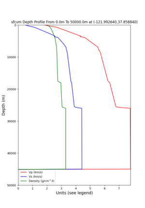
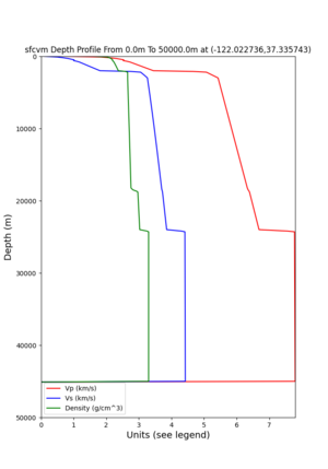
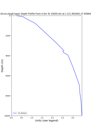
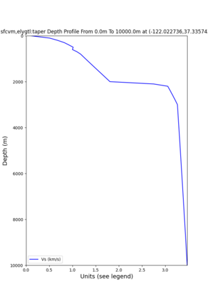
Validate with depth profiles
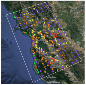
2 cybershake sites:
 RNHL :  3,RNHL,,37.858840,-121.992640
 CFCS :  1,CFCS,,37.335743,-122.022736
plot_depth_profile.py -s 37.858840,-121.992640 -b 0 -e 50000 -d vs,vp,density -v 100 -c sfcvm -o depth_RNHL
.png -i /var/www/html/UCVM_web_sfcvm/web/model/UCVM_TARGET

plot_depth_profile.py -s 37.335743,-122.022736 -b 0 -e 50000 -d vs,vp,density -v 100 -c sfcvm -o depth_CFCS
.png -i /var/www/html/UCVM_web_sfcvm/web/model/UCVM_TARGET
plot_depth_profile.py -s 37.858840,-121.992640 -b 0 -e 10000 -d vs -v 100 -c sfcvm,elygtl:taper -o depth_RN
HL_1.png -i /var/www/html/UCVM_web_sfcvm/web/model/UCVM_TARGET -L 100,500,500

plot_depth_profile.py -s 37.335743,-122.022736 -b 0 -e 10000 -d vs -v 100 -c sfcvm,elygtl:taper -o depth_CF
CS_1.png -i /var/www/html/UCVM_web_sfcvm/web/model/UCVM_TARGET -L 100,500,500
