Difference between revisions of "CCA"
From SCECpedia
Jump to navigationJump to search| Line 14: | Line 14: | ||
-115.4454, 36.0403<br /> | -115.4454, 36.0403<br /> | ||
| − | The grid spacing within the model is 500m and we use trilinear interpolation in between the grid points. | + | The grid spacing within the model is 500m and we use trilinear interpolation in between the grid points. The model covers depths down to 50km. |
Revision as of 19:02, 26 March 2015
Introduction
The Central California Seismic Project model (tentatively called "CCA") is a 3D velocity model comprised of the results of the full 3D tomographic inversions done by En-Jui Lee. This technique was first introduced in CVM-S4.26, which is a SCEC southern California velocity model.
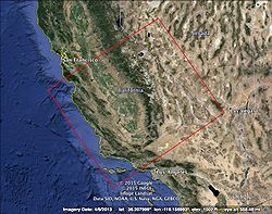
Coverage Region
The CCA model covers:
-120.0000, 33.3999
-122.9500, 36.6000
-118.2962, 39.3548
-115.4454, 36.0403
The grid spacing within the model is 500m and we use trilinear interpolation in between the grid points. The model covers depths down to 50km.
