Difference between revisions of "RSQSim CyberShake"
| Line 9: | Line 9: | ||
[[File:Rsqsim_rupture_mapping.png|thumb|right|400px|RSQSim Rupture Types]] | [[File:Rsqsim_rupture_mapping.png|thumb|right|400px|RSQSim Rupture Types]] | ||
| − | RSQSim catalogs generate ruptures on triangular elements. Those elements each have an associated UCERF3 fault subsection, which in turn has an associated fault section (e.g. Mojave S). GMPE comparisons use the associated UCERF3 subsections (after applying a filter to remove subsections for which only a few elements participate). | + | RSQSim catalogs generate ruptures on triangular elements. Those elements each have an associated UCERF3 fault subsection, which in turn has an associated fault section (e.g. Mojave S). GMPE comparisons use the associated UCERF3 subsections (after applying a filter to remove subsections for which only a few elements participate). |
| − | *Raw RSQSim Rupture: the actual simulator elements that ruptured in the RSQSim event. This is what is used in CyberShake. NOTE: we also filter all elements which are more than 100km from the nearest mapped "Significant Subsection" in order to filter out stray elements which could have ruptured co-seismically (perhaps unrelated) in another part of the state but don't contribute to hazard) | + | *Raw RSQSim Rupture: the actual simulator elements that ruptured in the RSQSim event. This is what is used in CyberShake (in the SRF, and for distance cutoff calculations). NOTE: we also filter all elements which are more than 100km from the nearest mapped "Significant Subsection" in order to filter out stray elements which could have ruptured co-seismically (perhaps unrelated) in another part of the state but don't contribute to hazard. [[:File:Rsqsim_stray_element_example.png|Example of rupture with stray elements to the N-W which are filtered out]]) |
| − | *Significant Subsections: mapped UCERF3 subsections for which at least 20% of each subsection (by area) participates in the rupture. This is what is used for GMPE comparisons, and some distance calculations in the database. | + | *Significant Subsections: mapped UCERF3 subsections for which at least 20% of each subsection (by area) participates in the rupture. This is what is used for GMPE comparisons, and some distance calculations in the database. |
Here is the structure for the RSQSim ERF: | Here is the structure for the RSQSim ERF: | ||
| Line 25: | Line 25: | ||
*In the Ruptures table, we are setting NumRows and NumCols to 0, but using the correct value for NumPoints. | *In the Ruptures table, we are setting NumRows and NumCols to 0, but using the correct value for NumPoints. | ||
*In the Ruptures table, Start/End Lat/Lon/Depth now represents the cube (in 3-d, non-rotated) which contains the entire rupture | *In the Ruptures table, Start/End Lat/Lon/Depth now represents the cube (in 3-d, non-rotated) which contains the entire rupture | ||
| − | *In the CyberShake_Site_Ruptures table, Site_Rupture_Dist now represents rRup (3-d site/source distance) to the GMPE comparison "Significant Subsections" surface, which can be greater than Cutoff_Dist. This field is usually used to look at amplitudes with distance, so the closest raw rupture surface distance may not be appropriate. This listed distance can be either less or greater than the actual raw rupture distance. Ruptures included in this table are all ruptures for which the raw rupture distance is less than the cutoff dist. | + | *In the CyberShake_Site_Ruptures table, Site_Rupture_Dist now represents rRup (3-d site/source distance) to the GMPE comparison "Significant Subsections" surface, which can be greater than Cutoff_Dist. This field is usually used to look at amplitudes with distance, so the closest raw rupture surface distance may not be appropriate. This listed distance can be either less or greater than the actual raw rupture distance. Ruptures included in this table are all ruptures for which the raw rupture distance is less than the cutoff dist. The raw rupture distance is used for cutoff distance checks. |
=== Input file changes === | === Input file changes === | ||
Revision as of 19:08, 7 February 2018
We are planning to perform CyberShake simulations using RSQSim as the ERF. This page documents the decisions and results.
Contents
Modifications from UCERF2 ERF
The biggest differences from the UCERF2 ERF is that RSQSim ruptures don't neatly fall into the source/rupture/rupture variation hierarchy, and the rupture surfaces are UCERF3 surfaces, so they fall on a triangular, not rectangular grid.
Rupture hierarchy
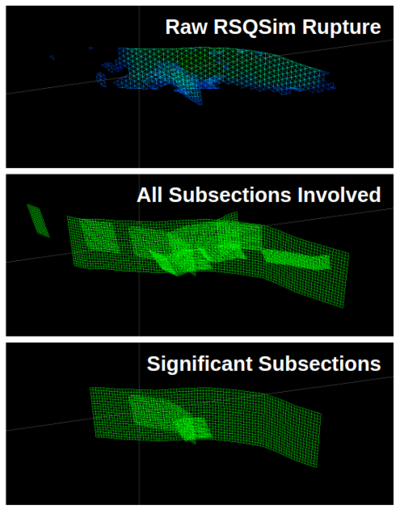
RSQSim catalogs generate ruptures on triangular elements. Those elements each have an associated UCERF3 fault subsection, which in turn has an associated fault section (e.g. Mojave S). GMPE comparisons use the associated UCERF3 subsections (after applying a filter to remove subsections for which only a few elements participate).
- Raw RSQSim Rupture: the actual simulator elements that ruptured in the RSQSim event. This is what is used in CyberShake (in the SRF, and for distance cutoff calculations). NOTE: we also filter all elements which are more than 100km from the nearest mapped "Significant Subsection" in order to filter out stray elements which could have ruptured co-seismically (perhaps unrelated) in another part of the state but don't contribute to hazard. Example of rupture with stray elements to the N-W which are filtered out)
- Significant Subsections: mapped UCERF3 subsections for which at least 20% of each subsection (by area) participates in the rupture. This is what is used for GMPE comparisons, and some distance calculations in the database.
Here is the structure for the RSQSim ERF:
- Source: all ruptures which involve the same set of UCERF3 fault sections (aka 'parent sections'), after mapping to "Significant Subsections". Source names are all of the sections involved, and sources are sorted alphabetically
- Rupture: an individual RSQSim rupture (with it's own full slip/time history) that occurred in the RSQSim catalog. Ruptures are sorted by magnitude (increasing)
- Rupture Variation: there is 1 rupture variation for each rupture, as each rupture has as slip/time history from RSQSim
Database changes
- In the Ruptures table, we are using the square root of the average element area for GridSpacing - basically, the side length if they were on a rectangular grid.
- In the Ruptures table, we are setting NumRows and NumCols to 0, but using the correct value for NumPoints.
- In the Ruptures table, Start/End Lat/Lon/Depth now represents the cube (in 3-d, non-rotated) which contains the entire rupture
- In the CyberShake_Site_Ruptures table, Site_Rupture_Dist now represents rRup (3-d site/source distance) to the GMPE comparison "Significant Subsections" surface, which can be greater than Cutoff_Dist. This field is usually used to look at amplitudes with distance, so the closest raw rupture surface distance may not be appropriate. This listed distance can be either less or greater than the actual raw rupture distance. Ruptures included in this table are all ruptures for which the raw rupture distance is less than the cutoff dist. The raw rupture distance is used for cutoff distance checks.
Input file changes
- Since the rupture geometry files also expect GridSpacing, NumRows, and NumCols, we are using the same approach as in the database. GridSpacing is replaced by AveArea, and NumRows and NumCols are replaced by NumPoints.
- Hazard curve/disaggregations require an ERF specific XML file, erf_params.xml. This file also references paths to 2 files, a mappings binary file and a simulator geometry file. If this file is relocated, referenced files must be copied and paths updated in the XML file. TODO: fix disagg code to work with this file rather than hardcoded UCERF2
Code changes
- A new version of DirectSynth, DirectSynth_RSQSim, was created, which takes in an input file consisting of a list of SRFs for processing.
Small-scale catalog, ERFID=42
Initially, we are using a small RSQSim catalog for testing on 4 CyberShake sites (USC, PAS, WNGC, SBSM).
Catalog details:
- Name: Bruce 2457
- Average element area: 1.35 km^2
- Min Mag Considered: 6.5
- Num Events: 41829 M>=6.5 events (2947 sources)
- Catalog Duration Used: 187,782.42 years
- More information: https://github.com/kevinmilner/rsqsim-analysis/tree/master/catalogs/rundir2457
Input file locations
- SRF files: /home/scec-02/kmilner/simulators/catalogs/rundir2457/cybershake_inputs
- Point files: /home/scec-02/kmilner/simulators/catalogs/rundir2457/cybershake_inputs
- Catalog/ERF Mappings: /home/scec-02/kmilner/simulators/catalogs/rundir2457/erf_mappings.bin
- ERF Metadata XML: /home/scec-02/kmilner/simulators/catalogs/rundir2457/erf_params.xml
Test seismograms
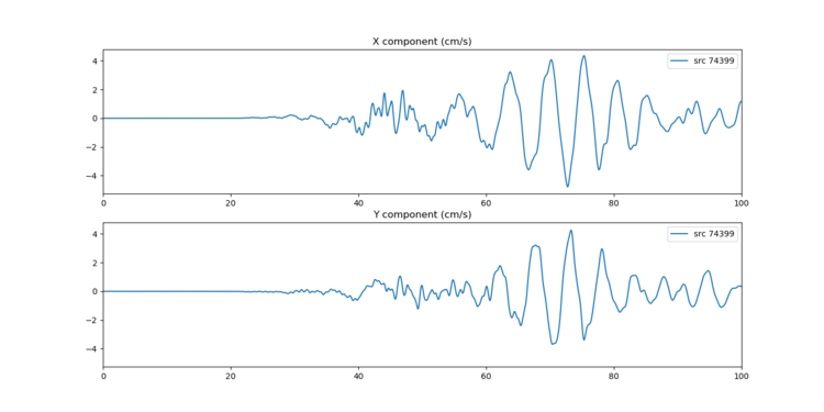
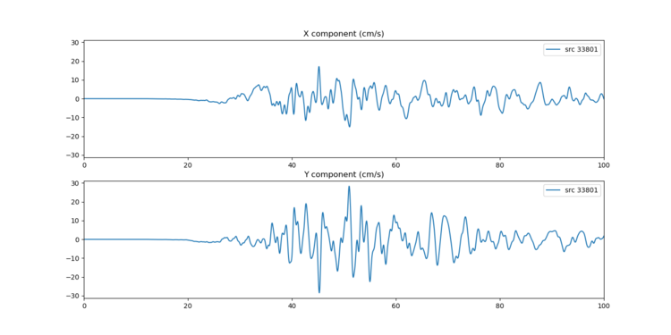
Seismograms were synthesized for site USC (1 Hz) for two RSQSim events.
