Difference between revisions of "Wills Map"
From SCECpedia
Jump to navigationJump to search| Line 1: | Line 1: | ||
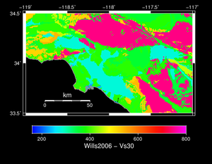
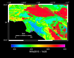
== Comparison of Wills Map 2006 versus 2015 == | == Comparison of Wills Map 2006 versus 2015 == | ||
| + | {| | ||
| + | | [[File:wills_2006.png|thumb|300px|Wills Map 2006]] | ||
| + | | [[File:wills_2015.png|thumb|300px|Wills Map 2015]] | ||
| + | |} | ||
== Description of Wills Digital Map == | == Description of Wills Digital Map == | ||
Revision as of 17:28, 29 June 2018
Comparison of Wills Map 2006 versus 2015
Description of Wills Digital Map
 2015 is the latest version that I am aware of. The supplementary data of the paper provides the map as a GIS shapfile (http://www.seismosoc.org/Publications/BSSA_html/bssa_105-6/2015105-esupp/index.html). I then rasterized it to a binary floating point file (which similar to the 2006 file, except with floats instead of short ints) using the gdal_rasterize command (http://www.gdal.org/gdal_rasterize.html).

The original and rasterized data is stored here on opensha.usc.edu:

/export/opensha-00/data/siteData/wills_2015

I suggest you use raster_0.00025.flt, which is rasterized with 0.00025 degree spacing (~25 meters). The raster_0.00025.hdr file contains the necessary coordinates for georeferencing it, but I'll summarize here:

The first location in the file is at:

x/longitude/ULXMAP = -124.406528862058
y/latitude/ULYMAP = 42.0090923024621

This is the upper left (northwest) point in the map.

numX/numLon/NCOLS = 41104
numY/numLat/NROWS = 37900

Grid spacing (both X and Y): 0.00025 degrees

Data type: 4-byte/32-bit little-endian floating point numbers

Mesh ordering: fast XY, so the first few points are:

    Index 0 (at byte 0): -124.406528862058, 42.0090923024621
    Index 1 (at byte 4): -124.406528862058+0.00025, 42.0090923024621 = -124.406278862058, 42.0090923024621
    Index 2 (at byte 8): -124.406528862058+0.0005, 42.0090923024621 = -124.406028862058, 42.0090923024621
    ...

