Lin Thurber CVM
From SCECpedia
Jump to navigationJump to searchThe Lin Thurber et al (2010) CVM is seismic velocity models of the California crust and uppermost mantle using a regional-scale double-difference tomography algorithm. The details are described in:
- Lin, G., C. H. Thurber, H. Zhang, E. Hauksson, P. Shearer, F. Waldhauser, T. M. Brocher, and J. Hardebeck (2010), A California statewide three-dimensional seismic velocity model from both absolute and differential Times, Bull. Seism. Soc. Am., 100, in press.
- FILE FORMAT DESCRIPTION
-117.7230 37.8242 1.00 250.00 0.00 5.0390 109.13 lon lat dep x y vp DWS (derivative weight sum)
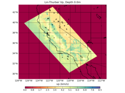
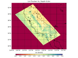
These preliminary maps are based on querying the model at an elevation offset of -1000.0m from MSL. We will need to add a DEM to UCVM in order to properly query this model by depth. The model is referenced using inverse bilinear interpolation of the original model boundaries.
As seen in the plots, the Vp model is higher resolution (~10km) than the Vs Model (~30km).

