CVM S4 Testing
Contents
Test 1
Create a grid file using ucvm makegrid.sh with these settings. This will search the LA basin region at 10km resolution.
 HOR_SPACING=0.001
 VERT_SPACING=10
 MIN_DEPTH=90
 MAX_DEPTH=110
 MIN_LON=-118.5
 MAX_LON=-117.5
 MIN_LAT=33.5
 MAX_LAT=34.5
Output file wc, showing 3M lines
3006003 9018009 59118059 out.grd
This file is contentated with itself. This will result in two calls to each point, but not consecutively. This tests whether the state-ful ness is reset when horizontal change is made.
Resulting populated file wc:
6012006 102204102 1124245122 cvms4test.res
10 row Test Case below:
Read this with python program into dataframes, then compare Vs for equilent query lines
       lon   lat     Z     surf  ...    cmb_vp    cmb_vs   cmb_rho  diff_second_call
0 -118.500  33.5  90.0 -586.131  ...  5423.895  3022.723  2721.433            -1.307
1 -118.499  33.5  90.0 -564.804  ...  5426.159  3022.984  2721.791            -1.308
2 -118.498  33.5  90.0 -490.265  ...  5428.422  3023.246  2722.148            -1.309
3 -118.497  33.5  90.0 -415.728  ...  5430.686  3023.507  2722.505            -1.309
4 -118.496  33.5  90.0 -449.495  ...  5432.949  3023.769  2722.863            -1.309
5 -118.495  33.5  90.0 -501.536  ...  5435.213  3024.030  2723.220               NaN
6 -118.494  33.5  90.0 -501.381  ...  5437.477  3024.292  2723.578               NaN
7 -118.493  33.5  90.0 -512.660  ...  5439.758  3024.555  2723.938               NaN
8 -118.492  33.5  90.0 -571.888  ...  5442.021  3024.816  2724.295               NaN
9 -118.491  33.5  90.0 -596.526  ...  5444.285  3025.078  2724.653               NaN
Overview
We have identified points where CVM-S4 queries are stateful, specifically in the GTL region (~100m depth). By this, we mean that if we query the same point twice, CVM-S4 (and UCVM) returns different Vp, Vs, and rho properties for each query.
To investigate this, we will run some tests to determine if all CVM-S4 regions are stateful, or only the GTL regions. We will also look at how large the differences
Initial Observed Differences
 ucvm_query -m cvmsi -f $UCVM_HOME/conf/ucvm.conf < in > out

 with the input being:

 -118.481000 34.312000 100.0000
 -118.481000 34.312000 100.0000
 -118.481000 34.312000 100.0000
 -118.481000 34.312000 100.0000

 returns the output:

  -118.4810    34.3120    100.000    386.051    397.973      cvmsi   2185.167    989.497   . . .
  -118.4810    34.3120    100.000    386.051    397.973      cvmsi   2435.524   1237.215   . . .
  -118.4810    34.3120    100.000    386.051    397.973      cvmsi   2435.524   1237.215   . . .
  -118.4810    34.3120    100.000    386.051    397.973      cvmsi   2435.524   1237.215   . . .
Search Regions
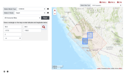
Define two search regions, one in LA Basin where CVM-S4 has a GTL defined. The second in the mojave where it is CVM-S4 background model. We will discretize at ~10.0m resolution. Basedon this link: Decimal Degrees, we'll descritze at 0.0001 resolution.
Search plans
We will use ucvm makemesh.sh script to create query points for each of these regions. We'll define a search layer from 80m to 120m at 10m resolution to determine whether the alternative values are at a single depth, or in a range of depths. We will add the original observed points to end of the file to ensure we reproduce the initial observations.
- Single query version
The first UCVM query will be a single query call for each point. It will output the expect ucvm results with useful results in the final columns.
- Double query version
The second ucvm query will contain duplicate points for each query. We will expect that in some cases, especially the observed data points above, the second query will return different values
- Triple query version
The third ucvm query will contain three duplicate points for each query. We will determine whether the second and third calls will create duplicates also.
- Query order tests
Query at 90m, query at 100m, query at 90m check if the two 90m queries are different.
- Query at different depths for same lat/lon
Indications are that two queries for the same lat/lon at say depth 20m, and at depth 100m, return different results than a single query at 100m.
Analysis
Post-processing scripts will determine:
- Total number of points in each file:
- Number of point in which first and second query are different
- Percent difference between first and second queries
- Location of points that produce differences
- Number of points in which second and third query are different
- Number of points in which first and third query are different
LABasin GTL Region
 34.5 -118.5
 33.5 -117.5
in KML:
<coordinates>
-117.5,33.5,0 -117.5,34.5,0 -118.5,34.5,0 -118.5,33.5,0 -117.5,33.5,0
</coordinates>
Background Region
35.5 -117.5
34.4 -116.5
<coordinates>
-116.5,34.5,0 -116.5,35.5,0 -117.5,35.5,0 -117.5,34.5,0 -116.5,34.5,0
</coordinates>
makemesh
We use the ucvm makemesh script to create the query points.
