CyberShake Study 14.2
CyberShake Study 14.2 is a computational study to calculate physics-based probabilistic seismic hazard curves under 4 different conditions: CVM-S4.26 with CPU, CVM-S4.26 with GPU, a 1D model with CPU, and CVM-H without a GTL with GPU. It uses the Graves and Pitarka (2010) rupture variations and the UCERF2 ERF. Both the SGT calculations and the post-processing will be done on Blue Waters. The goal is to calculate the standard Southern California site list (286 sites) used in previous CyberShake studies so we can produce comparison curves and maps, and understand the impact of the SGT codes and velocity models on the CyberShake seismic hazard.
Contents
Computational Status
Study 14.2 is scheduled to begin on February 3, 2014.
Data Products
Goals
Science Goals
- Calculate a hazard map using CVM-S4.26.
- Calculate a hazard map using CVM-H without a GTL.
- Calculate a hazard map using a 1D model obtained by averaging.
Technical Goals
- Show that Blue Waters can be used to perform both the SGT and post-processing phases
- Compare time-to-solution with Study 13.4. We define time-to-solution to be equivalent to the makespan of all of the workflows; that is, the time that elapses between when the first workflow is submitted (to HTCondor for execution) and when all jobs in all workflows have successfully completed execution, which includes calculation of all hazard curves. This metric includes any system downtime or workflow stoppages.
- Compare the performance and queue times when using AWP-ODC-SGT CPU vs AWP-ODC-SGT GPU codes.
Verification
For verification, we will calculate hazard curves for PAS, WNGC, USC, and SBSM under all 4 conditions.
Sites
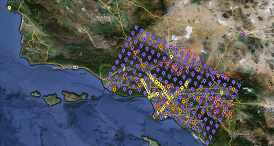
We are proposing to run 286 sites around Southern California. Those sites include 46 points of interest, 27 precarious rock sites, 23 broadband station locations, 43 20 km gridded sites, and 147 10 km gridded sites. All of them fall within the Southern California box except for Diablo Canyon and Pioneer Town. You can get a CSV file listing the sites here. A KML file listing the sites is available here.
== Computational and Data Estimates
