Moved:SCEC UGMS Committee Meeting
{{#externalredirect: https://www.scec.org/workshops/2014/ugms}}
- SCEC Committee for Utilization of Ground Motion Simulations Meeting 2
- Organizers: C.B. Crouse (URS) and Tom Jordan (SCEC/USC)
- Date: Monday, May 12, 2014 (10:00-17:30)
- Location: SCEC Boardroom, USC, Los Angeles, CA
- Participants: 25 (by invitation only)
Overview
The SCEC Committee for UGMS met on May 12th from 10 a.m. to around 5:30 p.m at USC/SCEC in Los Angeles, CA. At the meeting, Tom Jordan (USC/SCEC) and his team presented details of the CyberShake platform, which completed long period ground-motion simulations for the Los Angeles region. They presented how model uncertainties have been addressed so far and showed results of probabilistic and deterministic calculations. At the end of these presentations the committee discussed the next steps toward the goal of preparing long period ground motion maps for the Los Angeles region, a task that will be performed in collaboration with the SCEC GMSV TAG committee chaired by Nico Luco (USGS).
Agenda
Presentation slides may be downloaded by clicking each title. PLEASE NOTE: Slides are the author's property. They may contain unpublished or preliminary information and should only be used while viewing the talk.
| 10:00 | Welcome and introductions | C.B. Crouse |
| 10:10 | SCEC UGMS Committee overview (pptx) | C.B. Crouse |
| 10:30 | Overview of CyberShake and the SCEC ground motion simulation program (pdf) | T. Jordan |
| 11:30 | Group Discussion | All |
| 12:00 | Lunch | |
| 13:00 | Development of the SCEC Community Velocity Models (pdf) | T. Jordan |
| 13:30 | Comparisons among CyberShake models and with NGA models (pdf) | T. Jordan |
| 14:00 | Group Discussion | All |
| 14:30 | Break | |
| 15:00 | Plans for future CyberShake development (pdf) | T. Jordan |
| 15:30 | SCEC UGMS Committee | Executive Session |
| 17:30 | Adjourn |
Meeting Summary
Attendees
| Member Attendees (in person) C.B. Crouse - chair Tom Jordan Nico Luco Bob Bachman John Hooper Jacobo Bielak Charlie Kirchner Marty Hudson Marshall Lew |
Member Attendees (remotely) Ron Hamburger Art Frankel Norm Abrahamson Rob Graves Farzad Naeim Curt Haselton |
Members Absent Paul Somerville Jack Baker John Anderson |
Observers Andreas Skarlatoudis Fabio Silva Kevin Milner Brad Aagaard Nenad Bijelic Scott Callaghan Greg Deierlein En-Jui Lee Ting Lin Ricardo Taborda |
New Members
Marshall Lew and Marty Hudson, geotechnical engineers in AMEC’s Los Angeles office, were added as new members and both attended the meeting.
Project Overview
Crouse presented an overview of the pilot project, with the ultimate objective of producing long period response spectral acceleration maps of the Los Angeles Metropolitan region. The plan is to develop the maps in coordination with (1) the SCEC Ground Motion Simulation Validation Technical Activity Group (GMSV-TAG), (2) other SCEC projects, such as Cybershake and UCERF, and (3) the USGS national seismic hazard project. The maps would be submitted to the NEHRP Provisions Update Committee next code cycle. The tentative schedule was attached to the minutes of the 1st UGMS committee meeting in April 2013.
Technical Presentations
Much of the meeting was devoted to a discussion of the CyberShake platform for generating ground-motion simulations throughout Southern California. T. Jordan first presented an overview of CyberShake and the SCEC ground motion simulation program. Jordan followed with presentations on the SCEC community velocity models, and comparisons of ground-motion predictions from CyberShake and the empirical NGA equations. Jordan also showed that Cybershake was able to reproduce long period ground motions from recent local earthquakes. Jordan’s final presentation was plans for future CyberShake development, which included extending the frequency band to 1.3 Hz to better define 1-sec period motions.
Discussion
Deterministic/stochastic methods were mentioned as possible approaches to expand CyberShake’s ability to model higher frequency ground motions. This was not viewed as a necessary development for the successful production of the long period maps, because the maps at higher frequencies would continue to be developed using the traditional empirical ground- motion prediction equations. Jordan asked the committee whether long period maps for the vertical component would be useful to structural engineers, since CyberShake automatically generates this component in addition to the two orthogonal horizontal components. There was general agreement that it would be informative to see vertical ground motions as a check with provisions for the vertical component that were added to the 2009 NEHRP Seismic Provisions.
Nico Luco said (and Jordan confirmed) that unlike the USGS seismic source model, the CyberShake so far has only computed ground motions from ruptures on known active faults, whereas, the USGS also includes random earthquakes in its seismic hazard analysis. The question to be addressed is whether the random earthquakes increase the ground motion hazard at long periods by an insignificant amount. The USGS can quickly answer this question by examining the source deaggregations in its PSHA.
Another discussion topic was the performance measures that should be used in validating the simulations from CyberShake. Simulated ground motions will be compared to ground motions from the empirical NGA equations, as a benchmark, but that exercise does not necessarily represent a validation. Art Frankel questioned whether the absolute values from CyberShake could be trusted because of the uncertainties in the fault slip function. Art is using 3-D simulations to compute long period basin amplification factors for the Puget Sound region. The uncertainty in the source slip function needs to be considered. Rob Graves was not present to offer his views on the subject, but the topic will need to be addressed in the future.
Resolutions
The UGMS continued to affirm that the long period mapping project will proceed on two parallel tracks, in which PSHA/DSHA will be conducted from the 3-D numerical simulations using CyberShake and from the traditional empirical approach using the NGA-West equations. It was agreed that the results from the 3-D simulations could be used to refine the equations ultimately used in the empirical approach. The topic of how to use the results from the two approaches to construct the long period maps was discussed will be deferred until the results are generated.
Sensitivity studies will be conducted to evaluate the effect of the near surface velocity structure on the long period ground motions. Varying the mesh size in the near surface would address the issue, and depending on the results, some refinements the the near surface velocity structure may be made.
Focus of Next Meeting
T. Jordan will present results of the 3-D Cybershake model at selected sites in Southern California. The results will consist of 5% damped, horizontal component response spectra, generated according to the requirements of Chapter 21 in the ASCE 7 standard. The approach will be the same as used by the USGS in creating the national risk-targeted Maximum Considered Earthquake (MCER) maps at 0.2-sec and 1.0-sec periods. The probabilistic and deterministic MCER response spectra would be computed for periods in the 2.0 to 10 sec range, and compared with similar results generated using the NGA West2 equations.
Action Item
Crouse will select sites for the CyberShake calculation of the MCER response spectra, and N. Luco will provide the Matlab routine to do calculate the probabilistic MCER from the hazard curves. Crouse will provide details on the calculation of the maximum direction shaking component.
Date for Next UGMS Committee Meeting
The next UGMS committee meeting is tentatively scheduled for one day in the fall of this year in the time window, November 3 to November 21. A Doodle poll will be sent to members to arrange a date.
Data of Interest
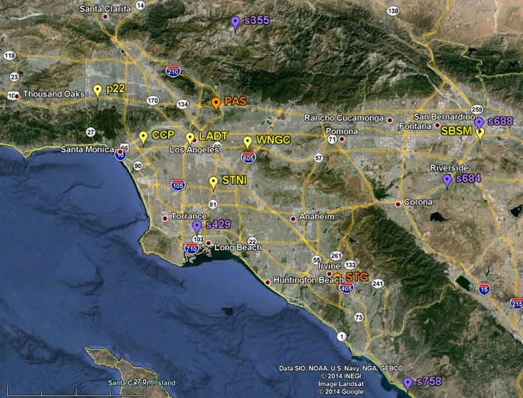
CyberShake Hazard Maps
| Site Name | NGA-1 3 second curve | NGA-1 5 second curve | NGA-2 3 second curve | NGA-2 5 second curve |
| LADT | LADT 3 sec | LADT 5 sec | LADT 3 sec | LADT 5 sec |
| CCP | CCP 3 sec | CCP 5 sec | CCP 3 sec | CCP 5 sec |
| P22 | P22 3 sec | P22 5 sec | P22 3 sec | P22 5 sec |
| s429 | s429 3 sec | s429 5 sec | s429 3 sec | s429 5 sec |
| STG | STG 3 sec | STG 5 sec | STG 3 sec | STG 5 sec |
| s684 | s684 3 sec | s684 5 sec | s684 3 sec | s684 5 sec |
| s688 | s688 3 sec | s688 5 sec | s688 3 sec | s688 5 sec |
| PAS | PAS 3 sec | PAS 5 sec | PAS 3 sec | PAS 5 sec |
| s758 | s758 3 sec | s758 5 sec | s758 3 sec | s758 5 sec |
| SBSM | SBSM 3 sec | SBSM 5 sec | SBSM 3 sec | SBSM 5 sec |
| STNI | STNI 3 sec | STNI 5 sec | STNI 3 sec | STNI 5 sec |
| WNGC | WNGC 3 sec | WNGC 5 sec | WNGC 3 sec | WNGC 5 sec |
| s355 | s355 3 sec | s355 5 sec | s355 3 sec | s355 5 sec |
