Difference between revisions of "CyberShake Study 2.2"
| Line 19: | Line 19: | ||
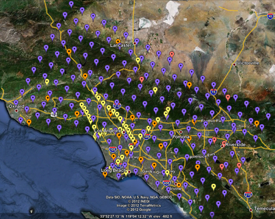
[[File:Study_2_2_sites.png|400px|thumb|left|Fig 1: Sites selected for Study 2.2. Purple are gridded sites, red are precarious rocks, orange are SCSN stations, and yellow are sites of interest.]] | [[File:Study_2_2_sites.png|400px|thumb|left|Fig 1: Sites selected for Study 2.2. Purple are gridded sites, red are precarious rocks, orange are SCSN stations, and yellow are sites of interest.]] | ||
| + | |||
| + | == Additional Information == | ||
| + | |||
| + | The science review slides are available [[Media:Science_Review.ppt| here]]. | ||
| + | The computational science review slides are available [[Media:Computational_Review.ppt| here]]. | ||
Revision as of 20:17, 10 October 2012
CyberShake Study 2.2 is a proposed study to calculate hazard curves under CyberShake 1.1 using CVM-S and the Graves and Pitarka (2010) rupture variations. We are reusing previously computed SGTs, so only the post-processing needs to be calculated. The goal is to calculate the same site list as for CyberShake 1.0 so we can produce comparison curves and maps.
Current Progress
47 sites have been completed before beginning the October 2012 production runs.
We began study 2.2 on October 8, 2012.
| Updated: 10/10/12 | |
|---|---|
| Sites complete: | 8 |
| Sites remaining: | 209 |
Sites
We have identified 268 sites to calculate, of which 45 are sites of interest, 25 are additional basin sites, 190 are 10 km gridded sites, and 8 are precarious rock sites. A spreadsheet with a list of these stations and their locations is available here.
Additional Information
The science review slides are available here. The computational science review slides are available here.
