Difference between revisions of "Geoinformatics Project"
| Line 22: | Line 22: | ||
We have selected the following Dates/Time for our calls. These call times were selected to avoid schedule conflicts with Tom’s teaching schedule. We apologize if these times conflict with your Spring 2014 commitments. | We have selected the following Dates/Time for our calls. These call times were selected to avoid schedule conflicts with Tom’s teaching schedule. We apologize if these times conflict with your Spring 2014 commitments. | ||
| − | + | All calls are schedule from 11am-12noon Pacific Time | |
#Thursday 6 February 2014 | #Thursday 6 February 2014 | ||
Revision as of 22:48, 19 March 2014
Geoinformatics: Community Computational Platforms for Developing Three-Dimensional Models of Earth Structure (EAR-1226343)
- PI: T. H. Jordan (USC)
- Co-PI: Y. Cui (SDSC)
- Co-PI: K. Olsen (SDSU)
- Co-PI: J. Tromp (Princeton)
Project Duration: Start Date 1 Sept 2012 - End Date: 30 August 2014
Contents
- 1 Project Calls
- 2 Geoinformatics Telecon March 2014
- 3 Geoinformatics Telecons February 2014
- 4 Geoinformatics Telecon Notes 2014
- 5 Geoinformatics Project at AGU Fall 2013
- 6 CVM-S4.26
- 7 Project Descriptions
- 8 Spring 2014 Project Targets
- 9 Collaborator's Web Sites
- 10 Fall 2013 Telecon Schedule
- 11 Related Entries
- 12 Recent Images
Project Calls
SCEC Geoinformatics Group plans to have two telecoms a month during the Spring 2014 semester.
On our Geoinformatics project, we are working towards several goals including:
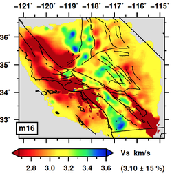
- Improve 3D velocity models for Southern California and Northern California.
- Improve global 3D velocity models.
- Improve computational tools and techniques to support full 3D tomography.
- Improve codes that support full 3D tomography.
We have selected the following Dates/Time for our calls. These call times were selected to avoid schedule conflicts with Tom’s teaching schedule. We apologize if these times conflict with your Spring 2014 commitments.
All calls are schedule from 11am-12noon Pacific Time
- Thursday 6 February 2014
- Thursday 20 February 2014
- Thursday 6 March 2014
- Thursday 20 March 2014
- Thursday 3 April 2014
- Thursday 17 April 2014
- Thursday 1 May 2014 SSA Meeting (No Call)
- Thursday 15 May 2014
These 7 calls will take us through end of the USC Spring Semester. We will select a summer call schedule once summer schedules are available.
The goal of these calls is to increase communications and collaborations among our widely distributed project groups. We will send a reminder just prior to the call. Please plan to join us for our next call:
Geoinformatics Telecon March 2014
Geoinformatics Telecons February 2014
Geoinformatics Telecon Notes 2014
Geoinformatics Project at AGU Fall 2013
CVM-S4.26
Project Descriptions
Summary. Precise information about the structure of the solid Earth comes from seismograms recorded at the surface of a highly heterogeneous lithosphere. Full-3D tomography based on adjoint and scattering-integral methods can assimilate this information into three-dimensional models of elastic and anelastic structure. These methods fully account for the physics of wave excitation, propagation, and interaction by numerically solving the inhomogeneous equations of motion for a heterogeneous anelastic solid. Full-3D tomography using adjoint and scattering-integral methods requires the execution of complex computational procedures that challenge the most advanced high-performance computing (HPC) systems. Current research is petascale; future research will require exascale capabilities.
We propose to establish an interoperable set of community computational platforms—vertically integrated systems of hardware, software, and wetware that will allow a significant community of investigators to employ the techniques of full-3D tomography to refine Earth structures. Two tomographic platforms will be built on highly scalable codes for solving the forward problem: the AWP-ODC 4th-order, staggered-grid, finite-difference code, which has been widely used for regional earthquake simulation and physics-based seismic hazard analysis (development led by K. Olsen), and the SPECFEM3D spectral element code, which is capable of modeling wave propagation through aspherical structures of essentially arbitrary complexity on scales ranging from local to global (development led by J. Tromp). A third platform, based on the Unified Community Velocity Model (UCVM) software developed by the Southern California Earthquake Center (SCEC), will provide a common framework for comparing and synthesizing Earth models and delivering model products to a wide community of geoscientists. These platforms will be deployed at the NCAR-Wyoming Supercomputing Center (NWSC). This proposal will be matched with allocation requests for use of Yellowstone at NWSC, to be submitted to NSF in March, 2012. The development and optimization of codes for Yellowstone and NWSC's next generation many-core hybrid systems will be led by Y. Cui.
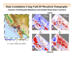
Intellectual Merit. This two-year project will support the sustained use of HPC systems by seismologists to create and refine Earth models at all scales. A specific project objective is to demonstrate the capabilities of full-3D tomography on both the AWP-ODC and SPECFEM3D platforms by creating Community Velocity Models (CVMs) for California that can be used in computing a statewide CyberShake hazard model. We will support on-going SCEC efforts led by two early-career scientists, P. Chen and C. Tape, to refine CVMs using earthquake waveforms and ambient-noise Green functions. We will investigate the iterative convergence of the tomographic models from disparate starting models using the UCVM platform to facilitate model comparisons, and we will work with SCEC groups in assessing the ability of refined CVMs to predict strong ground motions from large regional earthquakes. A second project objective is to move towards adjoint tomography of the entire planet by providing J. Tromp and his international collaborators with enhanced computational and data-management capabilities at NWSC. Our data management plans focus on establishing a well defined and repeatable data life cycle for Earth structure models needed to increase the scientific and engineering value of earthquake simulations.
Broader Impacts. Global 3D models will provide better images of mantle convection and its relationship to crustal tectonics and the geodynamo. Regional 3D models will more precisely constrain the plate- tectonic processes of lithospheric creation, deformation, magmatism, and destruction. Global and regional models will also improve imaging of seismic sources, including damaging earthquakes and nuclear explosions. Under the NSF-supported CyberShake project, SCEC researchers have developed computational pathways for generating physics-based seismic hazard models. The California CVMs derived by full-3D tomography will be the basis for a statewide CyberShake hazard model built upon a new version of the Uniform California Earthquake Rupture Forecast (UCERF3), which is scheduled for release in 2012. Our education plan is centered on using challenging scientific problems of compelling societal importance to engage and train a diverse STEM workforce, beginning at the undergraduate level and continuing through the post-doc level.
Spring 2014 Project Targets
On our Geoinformatics project, we are working towards several goals including:
- Improved 3D velocity models for Southern California and Northern California.
- Improved global 3D velocity models.
- Improved computational tools and techniques to support full 3D tomography
- Code improvements that support full 3D tomography
Collaborator's Web Sites
- University of Southern California Dept of Earth Sciences
- University of Wyoming Geophysics
- Harvard University Structural Geology
- Princeton University Theoretical and Computational Seismology
- San Diego Supercomputer Center HPC GeoComputing
- San Diego State University Geological Sciences
- University of Alaska Geological Institute
Fall 2013 Telecon Schedule
- Jan15th - Proposal Discussion
- March 5th - Inversion Overview
- March 19th - Phil Maechling - SCEC CVM Software Overview
- April 2nd - Norbert Podhorszki - Use of Adios files in inversions
- April 16th - Yifeng Cui - AWP-ODC-GPU development and simulations on Titan
- May 7th - No Call due to CSEP Meeting
- May 21st - No Call due to Blue Waters workshop
- June 4th - No Call due to SCEC Leadership Meeting
- June 18th - NSF Geoinformatics Solicitation
- July 2nd - Carl Tape - Quantifying numerical resolution for inversion (what's our minimum period?)
- July 16th - CIG/QUEST/IRIS Joint Workshop on Seismic Imaging of Structure and Source Workshop
- TBD - Jeroen Tromp - Building global scale velocity meshes for inversions
- TBD - Kim Olsen - Incorporating statistical models of small-scale heterogeneities into the CVMs
Related Entries
- Geoinformatics Project Internal Wiki (SCEC Login Required)
- CME
- SEISM
- PetaSHA3 Project
- Project_Discussion_Calls


